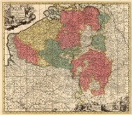
The Burgundian Imperial Circle included two basic territories - the Catholic Austrian Netherlands (approximately present-day Belgium and part of France) and the Protestant Republic of the United Netherlands (roughly present-day Netherlands). The territory was in the early modern period one of the main centers of European cartography, the collection documents map production in all major workshops in this area very well. Apart from that it contains a number of vedute of cities, canals, palaces, and gardens.
The Burgundian Circle
-
Austrian Netherlands I
Historical maps, general maps of all 17 provinces, maps of the Austrian Netherlands, plans of battlefields and maps of boundaries.
Original Shelfmark: Moll-0090.900,AA.T.XXIV
Moll's Catalogue: 1
-
Austrian Netherlands II
General maps of the Austrian Netherlands, maps of part of England, plans of battlefields and urban fortifications, military atlas (Crepy-Mainand).
Original Shelfmark: Moll-0090.900,AA.T.XXV
Moll's Catalogue: 1
-
Austrian Netherlands III
Special maps of the Austrian Netherlands - especially of Artois, Brabant. Sets of engravings of Brussels palaces and gardens, vedute and town plans.
Original Shelfmark: Moll-0090.900,AA.T.XXVI
Moll's Catalogue: 1
-
Austrian Netherlands IV
General and special maps of Flanders, Geldern, Hainaut, Cambrai (county and archdiocese), Limburg, Luxembourg, the territories of Mechelen, Namur, vedute and plans of cities, engravings of urban fortifications.
Original Shelfmark: Moll-0090.900,AA.T.XXVII
Moll's Catalogue: 1
-
Republic of the United Netherlands I
General maps, maps of Friesland, Zupthen and Geldern, Groningen. Plans and vedute of towns and thier fortifications, engravings of palaces and gardens.
Original Shelfmark: Moll-0090.900,AA.T.XXVIII
Moll's Catalogue: 1
-
Republic of the United Netherlands II
Maps of Holland, Amsterdam (city plans, engravings of buildings, streets, and port), Rotterdam, the palaces of Honslardyck and Rijswijk, urban fortifications plans.
Original Shelfmark: Moll-0090.900,AA.T.XXIX
Moll's Catalogue: 1
-
Republic of the United Netherlands III
Maps of Overijssel, Utrecht, Zeeland, engravings of the Soesdyck palace, a set of engravings of the Riviera of the Vechta River, vedute and town plans.
Original Shelfmark: Moll-0090.900,AA.T.XXX
Moll's Catalogue: 1


