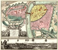
Maps and graphics of Bohemia, Moravia and Silesia are probably the only part of the collection someone paid any attention to in course of the 19th and 20th centuries. Comparison with the original state unfortunately shows considerable loss, the set was also partially amended. The current form therefore does not correspond with the original state, even so, it still contains a number of interesting works. Although the Moll Atlas was manufactured as late as in 1740s and 1750s, it contains the whole territory of Silesia, including the principalities lost after the wars of the Austrian Succession. Like the section on Austrian lands and Hungary, it is enhanced with a series of drawings by the author or the workshop using the sigla Geyer, which depict mines and ancient monuments. In map inventory catalogues these images are supplemented with all-embracing comments sent to Moll by experts familiar with local conditions (eg, for Moravia Joseph Ignaz Dismas von Hoffer). Attention should also be paid to an extensive collection of different variations of Comenius' maps of Moravia.
The Lands of the Bohemian Crown
-
Bohemia II
Special maps, plans and vedute of Prague and other Czech cities, maps of counties, engravings from Merian's topography, plans of the castle in Roudnice nad Labem.
Original Shelfmark: Moll-0090.900,AA.T.XXI
Moll's Catalogue: 1


